Unveiling the Most Detailed Global Image of the Red Planet
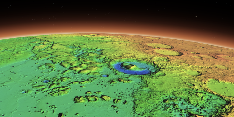
Caltech recently revealed a breathtaking global mosaic of Mars, generated using data from NASA’s Mars Reconnaissance Orbiter (MRO). This extraordinary image, the Global CTX Mosaic of Mars, enables both scientists and the public to explore the Red Planet like never before.
A Closer Look at Mars’ Stunning Features
The mosaic, comprising 110,000 images from MRO’s black-and-white Context Camera (CTX), showcases mesmerizing details such as cliffsides, impact craters, and dust devil tracks. Covering nearly 270 square feet (25 square meters) per pixel, this 5.7 terapixel masterpiece is the highest-resolution global image of Mars ever created.
Mars Mosaic: Monumental Achievement in Planetary Visualization
Produced by Caltech’s Bruce Murray Laboratory for Planetary Visualization, the mosaic took six years and tens of thousands of hours to develop. Its incredible detail has already been cited in over 120 peer-reviewed science papers based on a beta version, yet it remains accessible to all users. Jay Dickson, the image processing scientist who led the project, said the goal was “to lower the barriers for people who are interested in exploring Mars.”
Complementary Cameras Provide a Comprehensive View of Mars
MRO’s CTX is one of three cameras aboard the spacecraft, alongside the High-Resolution Imaging Science Experiment (HiRISE) and the Mars Color Imager (MARCI). While HiRISE offers color images of smaller surface features, CTX captures broader views of the terrain. MARCI, operated by the same team behind CTX, provides daily global maps of Mars’ weather at a much lower spatial resolution.
A Labor of Love and Science
Creating the mosaic required Dickson to develop an algorithm that matched images based on their captured features. He then manually stitched together 13,000 images that the algorithm couldn’t match. The remaining gaps represent parts of Mars not imaged by CTX or areas obscured by clouds or dust. Laura Kerber, a Mars scientist at JPL, praised the mosaic as “both a beautiful product of art and also useful for science.”
Updated Mars Mosaic: A New Way to Explore the Red Planet’s Wonders
Users can examine regions like Gale Crater, Jezero Crater, and Olympus Mons, or view impact craters across the planet. Rich Zurek, MRO’s mission project scientist, expressed excitement about the mosaic, saying it offers “a wonderful new way to explore some of the imagery that we’ve collected.” The mosaic was funded by NASA’s Planetary Data Archiving, Restoration, and Tools (PDART) program, which aims to develop new ways to utilize existing NASA data.
PLEASE READ: Have something to add? Visit Curiosmos on Facebook. Join the discussion in our mobile Telegram group. Also, follow us on Google News. Interesting in history, mysteries, and more? Visit Ancient Library’s Telegram group and become part of an exclusive group.


