From above, the Amazon can look like a single, unbroken organism: canopy, rivers, and not much else. That view helped cement an old assumption that large, settled societies could not take root across much of the basin. What is changing the picture is not a new ruin rising out of the trees, but a new way of seeing through them.
Archaeologists using LiDAR are documenting straight causeways, geometric ditches, enclosed plazas, platform mounds, and other built forms that do not read as accidents of erosion. In multiple regions, those features repeat in patterns that suggest planning at the scale of landscapes, not just households. The implication is not that the Amazon hid a stone empire that was somehow missed, but that parts of the forest once supported organized, durable settlement systems built largely from earth and wood, then reclaimed by vegetation when maintenance ended.
The “untouched” Amazon and the problem of visibility
European accounts from the sixteenth century sometimes described substantial riverside populations and cultivated zones, including descriptions preserved in Gaspar de Carvajal’s chronicle of Francisco de Orellana’s 1541–1542 voyage. Later travelers, looking for masonry, inscriptions, and monuments, found little of that sort and concluded that earlier reports were exaggerations. For a long time, the absence of stone architecture helped harden the idea that most of the rainforest could not sustain dense or persistent settlement.
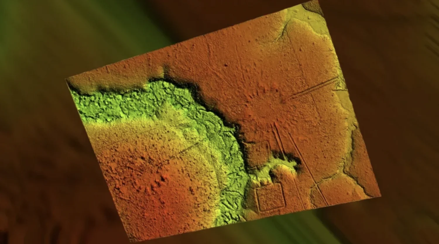
That reasoning had a built-in bias: in a humid forest, earth and timber decay, and the canopy hides low relief features that can be obvious on open ground. LiDAR changes the visibility problem. It does not “remove” the forest in any literal sense, but it can produce ground models that make subtle topography legible at scale, turning what looks like uninterrupted green into a map of ridges, ditches, raised roads, and platforms.
Acre’s geoglyphs and a long tradition of earth-building
One of the clearest signals comes from Brazil’s state of Acre, where researchers have documented more than 450 geometric earthwork sites, often called geoglyphs. Many are large, clean-lined enclosures shaped into circles and squares, sometimes connected by straight paths. Their distribution and shared design logic argue against isolated one-off construction. The sites are also central to Brazil’s UNESCO tentative listing for the “Geoglyphs of Acre”, which frames them as evidence of complex pre-Columbian occupation and landscape engineering.
Dating in this region varies by site and method, and claims of extreme antiquity are not evenly supported. Work published in Antiquity reports radiocarbon evidence consistent with major phases of earthwork construction beginning around 2,500 years before present and continuing for more than a millennium. That timeline matters because it places large-scale planned earthworks firmly within the broader pre-Columbian history of Amazonia, rather than as a late, isolated anomaly.
Bolivia’s Casarabe sites and “low-density urbanism”
The discovery that pushed this conversation into wider view came from the Bolivian lowlands. In 2022, a team led by Heiko Prümers reported in Nature that LiDAR mapping in the Llanos de Mojos revealed a settlement system associated with the Casarabe culture, dated in that work to roughly AD 500 to AD 1400. The mapped area was not enormous in absolute terms, about 200 square kilometres, but it was enough to show a structured hierarchy of sites linked by causeways and canals, with two particularly large centers reported at 147 hectares and 315 hectares.
The study described an urban form that does not match the dense stone-core model familiar from many textbook cities. The authors used the language of “low-density urbanism,” meaning settlement spread across a broad area with planned nodes, roads, and water infrastructure rather than a compact walled core. In 2025, further work in Nature discussed Casarabe land use and food production at regional scale, reinforcing that these were not fleeting camps but long-lived systems embedded in a managed landscape.
Population numbers are still debated and difficult to pin down from remote sensing alone. A 2025 analysis in PLOS ONE focused on constraining population estimates for Casarabe communities, underscoring both the scale implied by infrastructure and the uncertainty that remains when translating settlement footprints into headcounts.
Engineered landscapes, not just isolated villages
Across these regions, the emerging pattern is not a scatter of unrelated sites. It is connectivity. Straight causeways running for kilometres, repeated plaza-and-mound layouts, and defensive or drainage ditches aligned in ways that make sense as coordinated planning. Even where excavation is limited, the geometry itself is an argument. Random clearings rarely produce consistent right angles, repeated enclosure forms, and networks that link one node to the next.
This also helps explain why earlier fieldwork could miss the scale. Many of these constructions are low, earthen, and easily softened by vegetation and time. Without a map that can register regional patterning, a ditch can look like a local feature rather than part of a system.
Terra preta and the case for sustained soil management
The built landscape is only part of the evidence. Another durable trace is soil. Amazonian terra preta, or “dark earth,” is widely described as anthropogenic: enriched by charcoal and organic waste inputs over long periods, producing patches far more fertile than the surrounding, typically nutrient-poor soils. Reviews of dark earth research note both the strong evidence for human formation in many contexts and the ongoing debates about specific formation processes and variability across sites, as summarized in work on Amazonian dark earths in Frontiers and related journals and in more recent syntheses available through PubMed Central.
Terra preta does not prove “cities” on its own. It does, however, strengthen the argument for long-term occupation and land-use planning because it reflects sustained management, repeated inputs, and intergenerational continuity. In practical terms, it is the opposite of a brief, opportunistic use of the forest.
Researchers have also tested whether today’s forest bears a biological signature of past management. A major review on the long-term shaping of Amazonia by human societies, “The domestication of Amazonia before European conquest”, argues that human activity altered species composition in many regions, including concentrations of useful plants around habitation zones. That line of work is careful about causality, since modern economic cycles and later land use can also reshape distributions. But at minimum, it frames the Amazon not as a static wilderness, but as a mosaic where ecology and human history intertwine.
Collapse, abandonment, and a fast return to green
A central reason these systems can vanish from casual view is that the forest does not need to “destroy” them. It only needs time and the absence of maintenance. After European arrival, epidemics and disruption tore through Indigenous societies across the Americas. The scale varied by region, and numbers are contested, but scholarship often describes catastrophic losses over the first century and a half after 1492, a period examined in depth by historians such as Linda Newson in Proceedings of the British Academy. Economic history syntheses also cite demographic work suggesting many societies experienced losses on the order of 80 to 90 percent, as discussed in a widely cited review in the Journal of Economic Perspectives.
When population drops, labor-intensive infrastructure fails quickly. Causeways erode. Canals silt up. Raised fields collapse into wetlands. Plazas become indistinguishable from surrounding terrain. In a humid environment, that transition can be swift on archaeological timescales. The result is not an empty Amazon in the deep past, but an Amazon where the visible record of settlement became hard to read.
What “civilization” means in a rainforest context
The deeper argument here is partly semantic. If “civilization” is defined narrowly as stone cities, writing systems, and centralized monarchy, then most Amazonian societies will be excluded by definition. The evidence coming into focus points to complexity of a different kind: planned settlement networks, regional engineering, and durable land-use strategies that fit the constraints of forest and floodplain.
The Casarabe sites, the Acre geoglyphs, managed soils, and patterns of connectivity support the case for organized populations shaping terrain over generations. They also suggest that the Amazon’s archaeological invisibility was never the same thing as an absence of history.
Even with high-profile discoveries, LiDAR coverage for archaeology remains small relative to the basin’s vast area. That uncertainty is not just a hand-wave. In 2023, a team led by Vinícius Peripato reported in Science that modeling suggests more than 10,000 pre-Columbian earthworks may still be hidden beneath the canopy, with estimates ranging into the tens of thousands depending on assumptions and detection probabilities.
At the same time, sites are being destroyed faster than they can be documented in many regions, as deforestation and land conversion cut into areas that have never been systematically surveyed. The practical stakes are not only academic. If much of Amazonia is a cultural landscape as well as a biological one, then losing it means losing irreplaceable records of how people once built stable lives inside a demanding environment, without stone monuments to announce themselves