Rising seas erased vast coastlines after the last glacial peak, leaving archaeologists with a hard problem: how to test big claims with little surviving ground.
The idea of a “lost” pre–Ice Age civilization lives in a tense space between geology, archaeology, and popular myth. On one side is a plain fact: after the last glacial maximum, global seas rose on the order of 120–130 metres, flooding continental shelves that had once been dry land. On the other side is a leap that does not follow automatically: that what vanished beneath those waters must have included advanced civilizations, perhaps with cities, writing, and engineered monuments. The evidence for that second claim remains thin.
Still, the question persists because some real places do point to surprising early complexity, and some real floods did reshape whole basins quickly enough to displace communities. The best test case sits at the hinge of Europe and Asia, in a sea that has long invited stories of sudden loss.
The Black Sea Flood Hypothesis
In the late 1990s, marine geologists William Ryan and Walter Pitman argued that the Black Sea may have experienced a rapid change when Mediterranean water pushed through the Bosporus, turning what they described as a lower, less salty basin into the saltwater sea known today. The proposal, often called the Black Sea deluge hypothesis, drew on seafloor mapping, sediment cores, and the search for former shorelines. A longer technical discussion of the mechanisms and core evidence appears in Ryan’s paper on catastrophic flooding of the Black Sea.
Parts of the concept are widely accepted, even by researchers who reject a dramatic “waterfall” scenario. The Black Sea did reconnect with the Mediterranean during the Holocene, and its salinity history records a major transition. What remains disputed is pace, timing, and what the transition looked like on the ground. A review of Holocene marine transgression in the Black Sea lays out how sharply scientists differ over whether the change was sudden, incremental, or a mix that varied by location.
The archaeological implication is straightforward and limited. If low-lying shorelands were flooded quickly, settlements near the former waterline could have been displaced or destroyed. That possibility does not require cities or “civilization” in the later sense. It does suggest, however, that some human landscapes now sit underwater, and that the absence of sites on today’s coasts can reflect later inundation, not an empty past.
Echoes Beneath the Waves
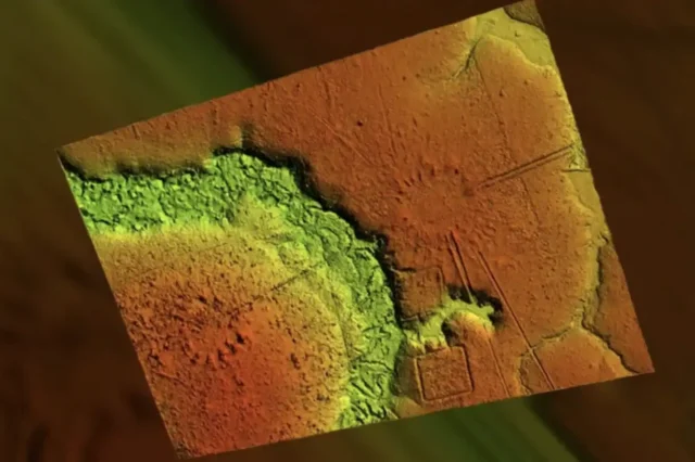
Over the past two decades, researchers have used multibeam sonar and remotely operated vehicles to map submerged terrain in many regions, including the Black Sea. Such surveys can reveal terraces, channels, and geometric shapes that look suggestive on a screen. The harder step is demonstrating that a pattern is cultural rather than natural, and then dating it securely.
On that score, the Black Sea has not produced a clear, peer-reviewed case for confirmed pre-Holocene architecture on the seabed. Claims tend to outrun documentation, and underwater context is unforgiving. Without in situ artifacts, stratigraphy, and reproducible dating, “structures” remain hypotheses, not findings.
What is plausible, and supported in a general way by coastal archaeology worldwide, is that Neolithic and late Mesolithic communities lived on shorelines that no longer exist. People followed water, game, and arable land. When the water moved, settlements moved too, leaving scattered traces that may now be buried under sediment.
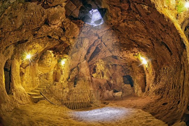
Göbekli Tepe and Early Monumentality
The strongest anchor for the broader argument is not underwater at all. It is on a hill in southeastern Anatolia: Göbekli Tepe, a UNESCO World Heritage site built by hunter-gatherers in the Pre-Pottery Neolithic, dated to roughly 9,600–8,200 BCE.
Göbekli Tepe matters because it forces precision about what “complex” means. Monumental construction, shared ritual space, and coordinated labor can exist without farming, pottery, or writing. UNESCO’s description emphasizes the site’s T-shaped pillars carved with animals, and the broader archaeological literature places it among the earliest known monumental complexes.
That does not, by itself, point to a vanished global civilization. It does show that human groups at the end of the last Ice Age were capable of organizing large projects, sustaining symbolic systems, and maintaining places that drew people together across time. Those are ingredients of later complex societies, but they are not the same thing as cities, states, or empires.
Some writers interpret Göbekli Tepe as evidence of a surviving lineage from a much older, lost society. The site can support a simpler reading that is also radical enough: social complexity did not wait for agriculture. In that sense, Göbekli Tepe is a challenge to older textbook sequences, but not a “smoking gun” for an advanced pre-Ice Age civilization.
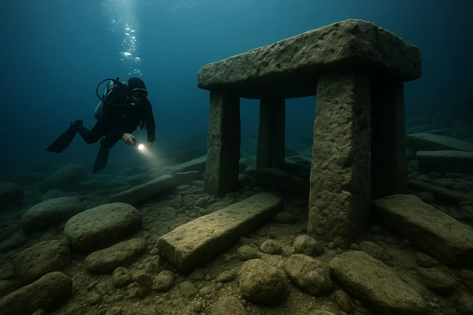
Atlantis, and the Pull of Underwater “Ruins”
Lost-land narratives tend to gather around dramatic underwater features. Plato’s Atlantis story appears in the dialogues Timaeus and Critias, and scholars generally treat it as a philosophical myth rather than a historical report, part of a broader discussion of how Plato used narrative in argument and moral instruction, as outlined in the Stanford Encyclopedia entry on Plato’s myths.
Modern “Atlantis candidates” often point to formations that look engineered. Three are frequently cited.
One is the so-called Yonaguni Monument off Japan. The debate there is unusually transparent: marine geologist Masaaki Kimura has argued for human modification, while other researchers, including Boston University geologist Robert Schoch, have argued the shapes are consistent with bedding planes and jointing in sandstone. National Geographic summarized this split in its report on the Yonaguni formations, noting Schoch’s view that natural processes can produce sharp, terraced geometry.
Another is the Gulf of Khambhat in India, where India’s National Institute of Ocean Technology announced early 2000s sonar findings interpreted by some as “city-like” remains. A central criticism has been methodological: key materials were recovered by dredging, which makes it difficult to prove that an object belongs to the mapped feature rather than being transported there by currents. That problem is laid out in the overview of marine archaeology in the Gulf of Khambhat, and it remains the core reason many archaeologists do not accept strong claims built on those finds.
A third is the Bimini Road near the Bahamas. It is visually striking: blocks arranged in a line. Yet the best-studied interpretation is geological. USGS geologist Eugene Shinn described the formation as naturally jointed beachrock and explained the “forensic geology” approach used to test whether stones had been moved in his paper on Bimini beachrock. The recurring pattern across these sites is not suppression of evidence. It is the same basic barrier: extraordinary claims need controlled context, artifacts, and dates that stay attached to a specific place.
The Younger Dryas Impact Hypothesis
The most dramatic “reset” theory in this arena is the Younger Dryas Impact Hypothesis, which proposes that an extraterrestrial event around 12,900 years ago triggered abrupt cooling, widespread fires, and ecological disruption. The hypothesis remains disputed in the scientific literature. A useful starting point for the evidence claimed by proponents and the major criticisms is the overview of the Younger Dryas impact hypothesis, which links to primary papers and replication debates.
One widely cited data point is a reported platinum anomaly in Greenland ice cores near the Younger Dryas onset, published in PNAS. That signal has been interpreted in different ways, including as a marker of a localized meteoritic event rather than a global catastrophe. The disagreement is not just about one proxy. It is about whether a coherent, reproducible suite of impact markers exists across sites and whether proposed mechanisms match known physics and geology.
Even if a cosmic airburst or impact contributed to climatic disruption, it would not automatically imply the destruction of an advanced civilization. It would, however, fit the more modest claim that rapid environmental shifts can shatter societies, concentrate survivors, and reshape what gets remembered.
Flood Stories and Cultural Memory
Flood narratives are widespread, but their meaning is slippery. The Mesopotamian tradition appears famously in the flood account within the Epic of Gilgamesh, preserved on clay tablets including one in the British Museum’s collection. South Asian tradition includes the story of Manu, summarized by Britannica in its entry on Manu, where a flood wipes out humanity except for the survivor.
Such stories can preserve impressions of real disasters, including local floods, storm surges, tsunamis, and river shifts. They can also spread because they are culturally useful narratives about morality, renewal, and survival. Archaeologists and historians generally treat them as sources about belief and memory, not straightforward records of specific events.
Why Proof Is So Hard Underwater
A major constraint is geography. If humans lived along coastlines for tens of thousands of years, then rising seas could have erased an enormous amount of early habitation. The scale of post-glacial drowning is why submerged landscapes matter, and why research has accelerated.
Doggerland, the lost landscape beneath the North Sea that once connected Britain to mainland Europe, is a rare place where submerged terrain, sediment archives, and artifact recovery come together. Archaeological and geophysical work has produced evidence of human presence and changing environments, and the project has also entered public-facing research through simulations such as the University of Bradford’s work on the final days of Doggerland. Historic England’s summary of the Unpath’d Waters initiative reflects a wider shift: underwater archaeology is moving from exceptional dives to systematic landscape study.
The lesson is not that a lost Ice Age civilization has been found. The lesson is that submerged ground can, in the right conditions, preserve human traces. It also shows what counts as evidence: tools and worked materials in context, dated layers, and multiple independent lines of support.
What the Evidence Supports, and What It Does Not
There is no conclusive proof of an advanced pre–Ice Age civilization. The strongest facts point to something more specific and more useful.
First, sea-level rise after the last glacial maximum likely submerged many of the places where people lived, so the archaeological record is biased toward higher ground. Second, late Ice Age and early Holocene sites such as Göbekli Tepe show that complex social organization and monument building can precede agriculture, which complicates older, linear stories about “progress.” Third, many underwater “ruins” claims persist because some natural formations mimic architecture, and because underwater context makes it hard to run the kinds of controlled tests that settle arguments on land.
The most forceful version of the lost-civilization thesis often adds a social claim: that mainstream experts are too lazy or too afraid to accept what is in front of them. The record does not support that. Archaeology is full of debates, reversals, and hard-won consensus changes, but those changes usually arrive with methods, data, and replication, not with bold interpretation alone.
If history books change on this subject, it will likely be for a narrower, sturdier reason: because submerged landscapes yield more verified settlements, and because early monumental sites keep expanding the known range of what hunter-gatherers could build and sustain. The real story, so far, is not a hidden global civilization. It is a growing recognition that much of early human life happened in places that the ocean later reclaimed, and that complexity has more than one pathway.