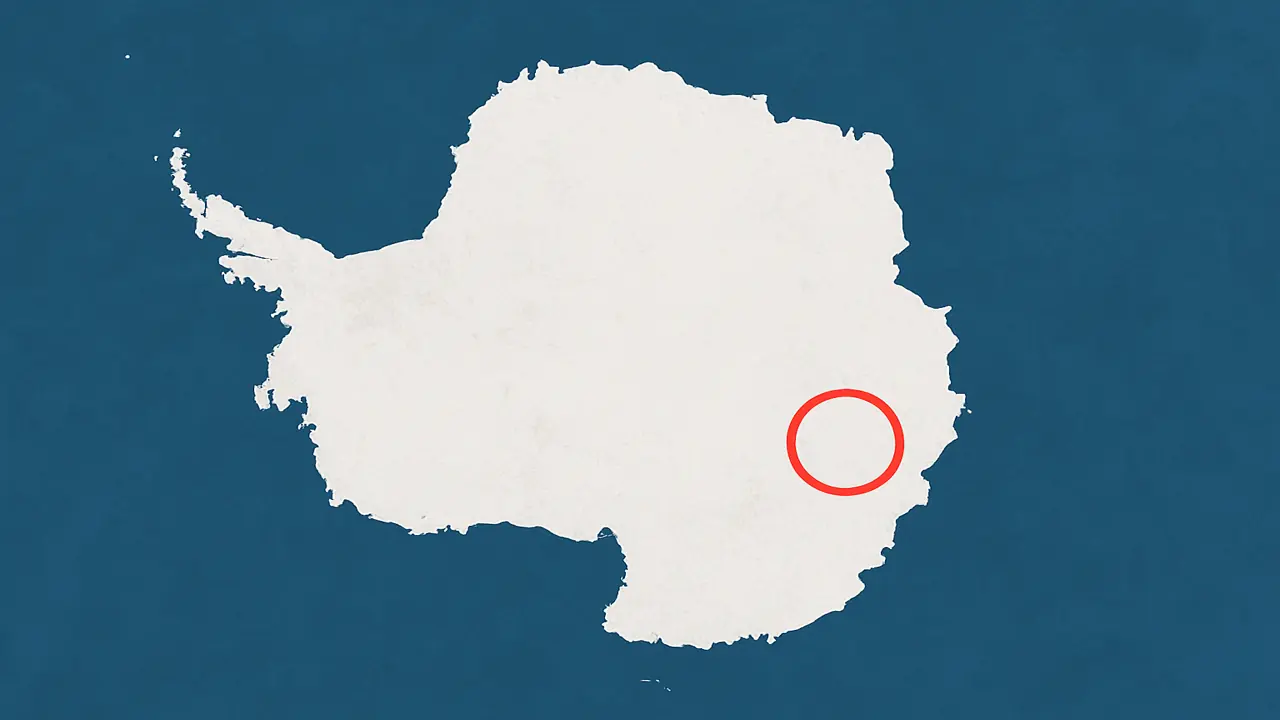
In the icy interior of East Antarctica, satellite instruments have picked up something buried far below the surface. There are no unusual features visible on the ground above. No exposed rock. No mountain chain. Just a flat stretch of ice in a region called Wilkes Land.
Yet whenever gravity-mapping satellites pass over this area, they register the same signal: a dense, circular mass hidden beneath more than two kilometers of ice. It doesn’t resemble any known geologic formation in Antarctica. Scientists call it the Wilkes Land Gravity Anomaly.
What lies beneath is still unknown. Some believe it could be the remnants of a massive asteroid impact, far older and larger than the one linked to the extinction of the dinosaurs. Others think it might be a buried uplift in the crust, or even the core of an ancient tectonic structure that predates the breakup of Gondwana.
Whatever it is, the anomaly has kept showing up in satellite data for more than two decades. And the more we learn about it, the stranger it seems.


A gravitational fingerprint hidden below the surface
The anomaly was first brought to attention during Earth gravity surveys conducted by NASA’s GRACE satellites in the early 2000s. GRACE, which stands for Gravity Recovery and Climate Experiment, works by measuring minuscule shifts in the distance between twin satellites as they pass over different regions of Earth. Where gravity is stronger, one satellite is pulled slightly more than the other. This data reveals the distribution of mass below Earth’s surface.
When GRACE passed over Wilkes Land, something unexpected happened. The satellites accelerated in a way that could only be explained by an enormous mass buried beneath the ice. Further measurements confirmed it was not an error. The same pull was detected again and again.
This region became known as the Wilkes Land Gravity Anomaly, a name that now represents one of the most enduring geological puzzles on Earth.
What could create such a massive signal?
Scientists quickly developed theories to explain the readings. One of the leading ideas is that this structure under Antarctica might be a buried impact crater, the scar left behind by an asteroid or comet that struck Earth over 250 million years ago. If this is true, the object responsible would have been twice the size of the one that created the Chicxulub crater, which contributed to the extinction of the dinosaurs.
The implications would be enormous. An impact of that scale could have unleashed global tsunamis, ignited wildfires across entire continents, and triggered a chain reaction of volcanic activity. Some geologists have even speculated that it might be linked to the Permian–Triassic extinction, the largest mass extinction in Earth’s history.
However, direct evidence of an impact is still missing. No shocked quartz, no melted glass, no layers of iridium have been recovered, mostly because no drilling has ever reached the suspected site. The entire theory rests on remote sensing data and gravitational modeling.
Not just gravity, but radar and magnetic signals, too
The mystery deepens when other datasets are taken into account. Airborne radar and magnetic mapping missions have also detected anomalies in the same region. These instruments show irregular magnetic patterns and unusual reflectivity beneath the ice. The readings are consistent with either a massive slab of denser-than-usual rock or a geophysical structure unlike anything previously seen in Antarctica.
Some scientists have proposed that the anomaly may be the result of an ancient geological uplift, formed by tectonic forces long before the continent froze over. Others suggest that it could be a remnant of a supervolcano whose cone has long since collapsed and disappeared beneath layers of compacted ice.
Still, none of these ideas explain why the anomaly is so round, so dense, and so isolated from other known features.
Why no one has drilled into Wilkes Land
The biggest barrier to understanding the structure under Antarctica is the ice itself. At Wilkes Land, the ice sheet is more than 2,500 meters thick. That’s deeper than the Grand Canyon. No existing drilling project has come close to penetrating this depth in such a remote and harsh environment.
Antarctic logistics are among the most difficult in modern science. The region sees some of the coldest temperatures on Earth, with high winds and no infrastructure. Getting a team of scientists, drilling equipment, and support personnel into Wilkes Land would be a multi-year operation costing hundreds of millions of dollars.
Even ground-penetrating radar, which has successfully mapped subglacial lakes and ancient riverbeds in other parts of Antarctica, provides only partial data here. The anomaly remains just out of reach, a ghost in the numbers.
Satellites still circle back to it
Despite the lack of direct access, Wilkes Land continues to be a focus for Earth observation missions. It is routinely used to calibrate instruments on new satellite platforms because its gravitational signal is so intense and consistent.
GRACE was retired in 2017, but its successor, GRACE-FO (Follow-On), is still monitoring changes in Earth’s gravitational field, including over Antarctica. Other satellites — such as ESA’s CryoSat and NASA’s ICESat-2, pass over the area regularly, measuring ice elevation and surface movement.
What they all share is a need to account for the pull from Wilkes Land. It affects radar returns. It adds noise to magnetometers. And yet, it has no face. The anomaly exerts influence without revealing its source.
Remote sensing
This situation highlights a broader challenge in geophysics. Remote sensing tools can measure gravity, magnetism, and radar reflections with exquisite precision, but they cannot tell us exactly what lies underground. The data must be interpreted, and interpretations always depend on models, assumptions, and what we expect to find.
In the case of the structure under Antarctica, nothing about it aligns with conventional expectations. It is too dense, too wide, too circular. If it is an impact crater, it is one of the most perfectly preserved ever detected, and yet there are no signs of a crater rim, ejecta, or deformation in the overlying rock layers.
That leaves us with a persistent anomaly, real enough to move satellites, yet invisible to the human eye.
What scientists hope to learn next
Some scientists believe it’s time to take a closer look at Wilkes Land. There have been proposals to send long-range radar drones across the ice, or even to drill down using equipment similar to what was used at Lake Vostok. But the logistics are difficult, and the cost is high.
Others think the answers might already be buried in the data we have. With better tools for processing satellite measurements and more advanced models of the Earth’s crust, they believe we may be able to piece together what lies below without setting foot on the ice.
What’s at stake is more than just an explanation for an unusual gravity signal. If this is the scar of an ancient impact, it might hold evidence of a global catastrophe, perhaps even one that shaped the evolution of life. If it is something else, it could reveal parts of Earth’s interior that have been hidden for hundreds of millions of years.