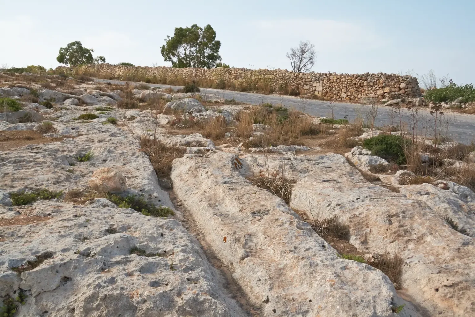
Parallel grooves run across exposed limestone in Malta, sometimes branching into a tangle of routes. Some are deep enough to make an ordinary wheeled cart seem an unlikely explanation. The vehicles have vanished, leaving the marks to tell their side of the story.
Usually called cart ruts, these tracks have prompted a question that sounds simple until you stand over one: could repeated journeys really wear a channel so deep into stone?
Researchers have modelled how loaded wheels might wear wet limestone. Others have proposed that the grooves began as deliberately cut field furrows. Both explanations depend on a landscape that looked different from the bare rock exposed today.
A cart with a practical limit
In a 2008 study published in Antiquity, Derek Mottershead, Alastair Pearson and Martin Schaefer examined the ruts through geomorphology, the study of landforms and the processes that shape them.
Their model found that a two-wheeled cart with a gauge of about 1.40 metres, carrying moderate loads, could cut into limestone in wet conditions. Gauge is the distance between the wheels’ tracks. The researchers used it to reconstruct a cart that could fit the grooves.
The authors also considered ground clearance. In their reconstruction, a cart could continue deepening a route until grooves approached its clearance of 0.675 metres. After that, it would need another route. This offers a practical explanation for multiple adjacent tracks: a heavily worn passage eventually becomes inconvenient.
Under that model, a driver would eventually have to choose a fresh strip of ground. Repeated diversions could leave several routes beside one another, producing the tangled pattern visible today.
Could the tracks have begun as fields?
Claudia Sagona’s 2004 paper in the Oxford Journal of Archaeology proposed that the grooves were deliberately made field furrows. Drawing on comparative ethnographic and archaeological evidence, she associated their creation with pressure to expand cultivable land during Malta’s Temple Period.
If Sagona’s proposal is right, the grooves should make sense as part of cultivated ground. The wheel model instead needs routes that vehicles could use and rock they could wear down. Their different predictions make the surrounding landscape as important as the grooves.
The Temple Period date is part of Sagona’s farming interpretation; the age of each set of tracks still needs evidence from its own surroundings.
Looking for tool marks in the limestone
Mottershead’s later paper, The Origin of Maltese Cart-Ruts, scrutinised claims that marks on rut walls proved hand cutting. He compared the proposed tool marks with exposed surfaces in ancient quarries at Misraħ Għar il-Kbir and Imtaħleb, where stone cutting was independently evident.
His search did not reveal comparable marks. He argued that the supposed tooling evidence was inconclusive: weathering might have erased real tool marks, while differences within the limestone could produce surfaces that resembled them.
The paper also described a transport sequence beginning in soil over bedrock. Traffic removes the soil along a route, exposes the rock and continues abrading it. Today’s bare limestone would then preserve only the later stage of a much longer process.
Who used the routes, and when?
Curiosmos has previously included Malta’s tracks in a roundup of archaeological puzzles. The studies go further, asking whether a vehicle would fit, how limestone would wear and whether cultivation better explains the pattern.
The wheeled-transport model is useful because it explains how a cart could fit and deepen the grooves, including why another route might be needed. Finding out who drove it, what it carried and when requires a different kind of evidence: remains and deposits associated with the tracks.
What if the apparent network preserves successive detours rather than a road planned all at once? That possibility follows from the clearance model. Mapping the depths and intersections alongside former soil cover and nearby dated remains could help test it. Malta’s tracks still leave room for several explanations, but their measurements give each one something concrete to answer.