The desert north of Arabia has kept a Roman military story out of sight for almost two thousand years. Now three angular traces in the landscape are giving archaeologists a possible route to follow.
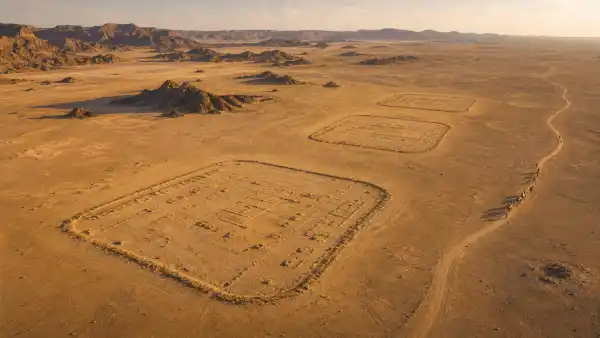
Researchers working with satellite imagery have identified three Roman marching camps in the Harrat al-Shaam region, close to the ancient frontier of the Nabataean Kingdom. The camps were not permanent fortresses. Their compact, playing-card shapes are the signatures of temporary bases built by an army on the move.
The discovery matters because the camps appear to record a campaign that is barely visible in the surviving written sources. Their position suggests that Roman troops crossed the desert during the annexation of Nabataea in AD 106, when the kingdom became the Roman province of Arabia Petraea.
The shapes visible from space
The camps were found by examining satellite images rather than by beginning with a large excavation. Even after centuries of erosion, their outlines remain legible. Each is roughly rectangular with rounded corners and entrances set into the perimeter, a layout familiar from Roman military camps elsewhere in the empire.
The two eastern camps are separated by roughly 37 kilometres. A third lies farther west, about 44 kilometres from the middle camp. That spacing is not proof of a single march, but it is compatible with an army establishing overnight positions at regular intervals. The western camp is larger, which may reflect a different stage of the movement or a force with more animals and equipment.
The walls are now low banks and faint lines. There are no towering stone gates to photograph. That is part of the point: a marching camp was designed to be occupied briefly, then abandoned. Soldiers could dig or mark a defensive perimeter, organise the interior and move on. Once the army left, wind and weather did the rest.
A campaign with no surviving battle narrative
The timing is the most important clue. In AD 106, the Roman emperor Trajan annexed the Nabataean Kingdom after the death of its king, Rabbel II. The Nabataeans controlled Petra and a network of trade routes linking the Levant, Arabia and the Red Sea. Roman sources record the political change, but they do not give us a complete day-by-day account of how troops moved through the interior.
The newly identified camps may fill part of that gap. Their alignment avoids the most obvious route through Wadi Sirhan and instead follows a more direct line across the desert. That does not mean archaeologists have reconstructed the entire invasion. It does suggest that a Roman force knew how to cross country that later maps tend to treat as empty.
The location also raises questions about logistics. A camp in this environment needed water, fodder and a way to keep animals moving. The force may have included cavalry, pack animals or camels, not only infantry. The shape of the largest camp could eventually help researchers estimate how many people it accommodated, but those estimates will remain provisional until fieldwork tests the satellite interpretation.
Why satellite archaeology is changing the map
Desert archaeology has always depended on seeing relationships between sites. A single pottery scatter can tell us that people passed through. A chain of camps can show how an army planned a route. Satellite imagery makes it possible to search for those patterns across enormous areas before excavation begins.
It is also a way to find places that are not dramatic on the ground. A traveller could walk past a low, eroded bank without recognising its geometry. From above, the same bank forms a deliberate enclosure. Researchers can compare the outline with known Roman camps, measure distances, identify possible entrances and then decide where a visit or geophysical survey would be most useful.
That remote view has limits. An image cannot by itself tell us exactly when a camp was built, how long it was occupied or which unit used it. Similar shapes can have different histories. The strongest case will come from combining the satellite evidence with ceramics, radiocarbon samples, inscriptions, metalwork and local knowledge of the terrain.
A route, not yet a complete invasion story
The discovery should be described carefully. The camps are Roman, and their arrangement is consistent with a military movement. The link to Trajan’s annexation of Nabataea is a compelling historical interpretation, not a sentence written on one of the walls.
Future work may find more camps between the three already known. It may also show that one site belongs to another campaign or was reused later. If the chain continues, the desert could reveal a Roman operational map that no ancient author preserved.
For now, the most valuable result is simpler. The northern Arabian desert was not a blank space between the famous centres of Petra and the Roman world. It was a landscape crossed by organised forces, supplied through difficult terrain and marked by temporary architecture. The outlines are faint, but they have survived long enough to reopen a chapter of the annexation of Nabataea.