On Al Sinniyah Island, the most important evidence may be the part no one can see yet.
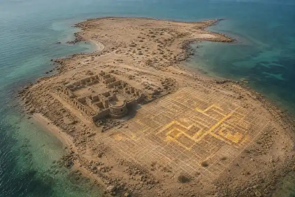
A team of researchers from Khalifa University has used high-resolution ground-penetrating radar to map areas near an ancient Christian monastery and the remains of one of the oldest pearling settlements in the Gulf. The survey detected sharp subsurface anomalies that could represent intact walls or other large structures.
The results do not prove that a lost city has been found. They do show that the island contains more archaeology beneath the sand than the visible ruins reveal, and they offer a non-invasive way to decide where excavation is most worthwhile.
A settlement at the edge of the Gulf
Al Sinniyah lies off Umm Al Quwain in the United Arab Emirates. Archaeologists have already identified a sixth-century Christian monastery on the island, along with the remains of a substantial settlement connected to pearling and maritime trade.
The site has been associated with Tu’am, a place mentioned in historical sources as an important settlement in the Gulf. That identification remains a subject for research rather than a label that can simply be stamped onto every structure on the island. The radar work is useful precisely because it can test how large and organised the settlement was before excavation disturbs it.
Researchers examined three rectangular zones using a three-dimensional ground-penetrating radar survey. The instrument sends electromagnetic pulses into the ground and records changes caused by buried walls, floors, voids or differences in sediment. It cannot read inscriptions through the sand. It can, however, reveal a plan that would be difficult to recognise from the surface.
What the radar found
The survey produced several pronounced anomalies. Their shape and continuity suggest that some may be archaeological structures rather than random changes in the soil. The most promising targets appear to be large enough to justify closer investigation, although the published report does not identify them as a palace, church or city wall.
That restraint matters. A radar image is an interpretation of reflected signals, not a photograph of a buried building. Stones, compacted earth, modern debris and natural layers can produce similar responses. Archaeologists must compare the radar pattern with the site’s geology and with the results of carefully placed test trenches.
The advantage is that the survey preserves the wider layout. Before ground-penetrating radar, a team might excavate a small area and discover an interesting wall without knowing how it fits into the settlement. A three-dimensional map can reveal alignments, street-like spaces and building footprints, then guide the first cut into the ground.
The monastery is only part of the story
The monastery has drawn understandable attention because it is an unusually clear reminder that Christian communities lived and worshipped along the Gulf before the rise of Islam. Yet a religious building cannot explain the entire island.
A settlement supporting pearling needed storage, workshops, homes, wells, cooking areas and places to process goods. It also needed connections to the sea. The radar anomalies could belong to those ordinary but essential spaces. If so, they may tell us more about how people lived than a single monumental building could.
The island’s position is also important. Pearling was not an isolated activity carried out by a few divers. It was part of a network that linked boats, crews, merchants and communities across the Gulf. Archaeology beneath the sand may reveal how that network was organised and how long the settlement remained active.
Why the Tu’am connection needs care
Tu’am is an attractive historical name because it offers a possible link between texts and the archaeological landscape. But the name cannot be used as a shortcut to certainty. The radar data do not contain a sign saying “Tu’am,” and the identification must be tested against chronology, settlement size, material culture and the location described in historical sources.
The strongest article therefore asks a question rather than announcing a discovery: could the buried structures help clarify whether Al Sinniyah was the major Gulf settlement later remembered as Tu’am?
That question gives readers a story with real stakes. It also avoids the familiar cycle in which every buried wall becomes a “lost city” before a single trench has been opened.
The next step is targeted excavation
The team spent about a month collecting field data, and the research has been published as “Reconstructing history: 3D high-resolution GPR analysis based on SAR discoveries in the ancient Al Sinniyah Island of Umm Al Quwain.” The next stage should combine the radar map with excavation, ceramic study, environmental sampling and, where possible, absolute dating.
If the anomalies are walls, excavation can establish their construction method and date. If they are floors or storage areas, they may preserve objects linked to pearling and trade. If some prove natural, that result will still improve the island’s archaeological map and prevent future work from wasting time in the wrong places.
Al Sinniyah is valuable because the visible monastery has already shown that the island mattered. The radar now suggests that the surrounding settlement may be waiting just beneath the surface. The discovery is not a confirmed lost city. It is a well-defined invitation to look more carefully.
Sources
- The National, “Radar helps shed new light on major human settlement at ancient UAE site”
- Khalifa University research paper, “Reconstructing history: 3D high-resolution GPR analysis based on SAR discoveries in the ancient Al Sinniyah Island of Umm Al Quwain, UAE.”