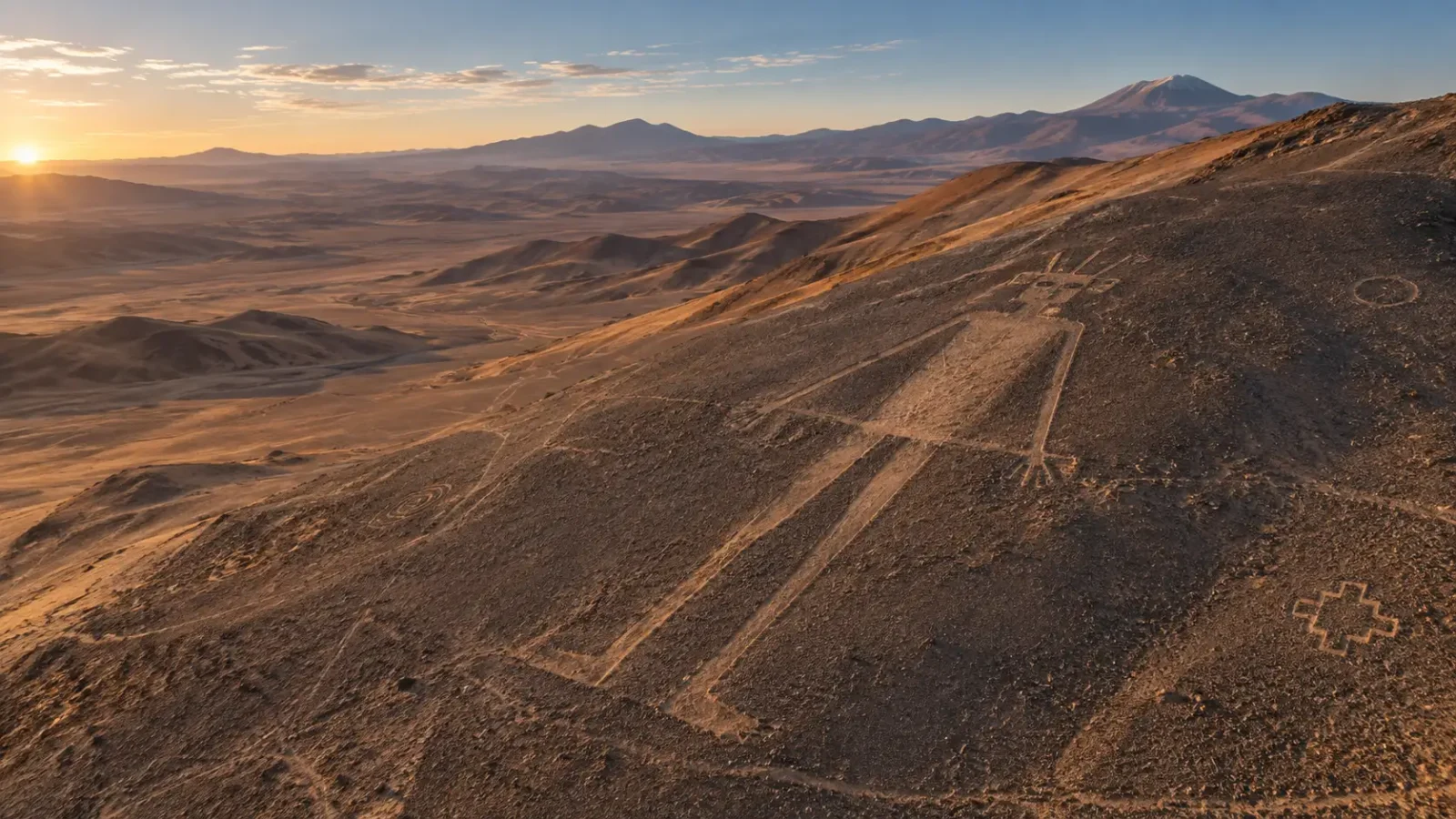
High on Cerro Unita, a human figure stretches across the desert slope. Its head carries a square shape with lines radiating outward. From the air, the Atacama Giant can look like a drawing from another world. On the ground, it belongs to a much older human landscape of routes, camps and monumental marks.
The geoglyph’s official names are Gigante de Atacama and Gigante de Tarapacá. What it represents has not been settled. The desert setting, however, gives archaeologists more to work with than the outline alone.
Drawing with the desert surface
Geoglyphs are made by changing the ground. In northern Chile, artists scraped away the darker crust to reveal lighter soil, piled stones into lines or combined both methods. The dry climate and sparse vegetation help the designs endure.
Keep exploring
Continue with Curiosmos
UNESCO’s Tentative List entry for the Pintados complex describes both methods and includes Cerro Unita among the region’s major geoglyph areas. The Giant was part of the terrain, on a slope visible from below, rather than a portable image viewed at close range.
Caravans across northern Chile
Researchers often study the region’s geoglyphs alongside the paths that crossed the desert between inland oases, the Andes and the Pacific coast. A study in Chungara describes designs near routes and temporary camps, especially during the Late Intermediate Period, roughly AD 900–1450. Llama caravans carried goods across this arid interior.
Near the Pintados figures, excavations have found small caravan camps. UNESCO reports evidence of exchanges involving maize, textiles, dried fish and shells. Cerro Unita is not part of Pintados, but both belong to a northern Chilean landscape where people travelled, traded and left marks beside their routes.
Not every geoglyph had to serve the same purpose. Some may have helped mark a route; others may have been places for offerings or community gatherings. A figure could have carried more than one meaning as people passed it over generations.
Who is the figure?
The radiating lines around the head have prompted suggestions of a sun or sky deity. They might also represent a headdress or another feature whose meaning has been lost. Calling the figure a “sky god” goes beyond what its outline alone can establish.
Archaeologists compare geoglyphs with nearby images, ceramic and textile designs, routes, settlements and objects from associated camps. They ask how a figure sits on the land: what can be seen from it, who might have approached it and how the slope shaped the view.
That context can narrow the possibilities without supplying a name. The Atacama Giant may have represented a powerful being, an ancestor, a traveller or a community symbol. Its makers left no inscription explaining the image.
A landmark seen while moving
A geoglyph is easy to understand as a picture from above. Its original audience may often have seen it while walking along the ground. From a route below, the huge body and marked head would have appeared against the slope as people crossed the desert.
What if the figure was meant to be encountered in motion? Its placement, size and orientation could have worked together as a landmark or ceremonial presence. That idea fits the wider evidence for travel through the region, though the exact experience of ancient visitors is impossible to recover.
The Atacama Giant shows how communities used the desert surface as a place for public images and memory. The design was made by human hands, using soil and stone, and its setting connected it with the people who knew how to cross this landscape. The unanswered question is what those travellers saw in the figure when it first came into view.
For comparison, Curiosmos has looked beyond the famous lines to the wider Nazca culture.
Sources
- UNESCO World Heritage Centre, Pintados Geoglyph Archaeological Complex.
- Chile’s National Monuments Council, Gigante de Atacama.
- Luis Briones, Geoglifos del Norte de Chile, Chile National Monuments Council.
- Chungara, study of Hispanic geoglyphs in the Atacama Desert.
- CSIC/INCIPIT, research on geoglyphs, caravan routes and travel across the northern Atacama.