Update — August 2026: A new Nature study has now mapped 432 earthworks across 4,497 square kilometres of southwest Amazonia, 396 of them previously undocumented. The researchers use that sample to estimate that more than 20,000 earthworks may exist across the wider Aquiry cultural landscape. The estimate is a model, not a count of 20,000 excavated sites. Nature’s report explains the new findings.
A laser survey of southwestern Amazonia has changed the scale of an old archaeological question. The aircraft did not reveal a hidden stone city, and it did not count 20,000 monuments one by one. What it did reveal was a dense pattern of ancient earthworks beneath the forest canopy—enough for the research team to estimate that more than 20,000 may exist across the wider Aquiry cultural landscape.
The distinction matters. The new paper, published in Nature, documents 432 earthworks in the LiDAR data. Only 36 of them were already known. The larger number is a model-based estimate drawn from the density and distribution of those finds, not a claim that 20,000 sites have already been excavated or even individually located.
What the lasers actually saw
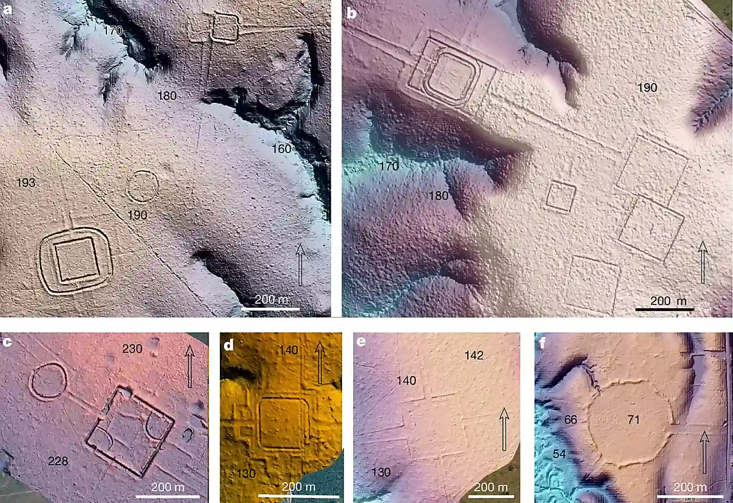
LiDAR—short for light detection and ranging—maps the shape of the ground by firing enormous numbers of laser pulses from an aircraft and measuring their return. A forest canopy still complicates the data, but enough pulses reach the ground to produce a detailed terrain model. Low ditches, raised embankments, platforms and roads that are almost impossible to recognize from the forest floor become readable as shapes.
The team flew survey lines over 4,497 square kilometres in Brazil’s southwest Amazon. The resulting models recorded geometric enclosures and related earthworks around places including Rio Branco, Lábrea, Boca do Acre and Carauari. Many are large enough to be understood as communal or ceremonial centres rather than casual clearings. Their form is the point: circles, squares, octagons and connected compounds recur across the landscape.
Researchers associate much of this built environment with the Aquiry cultural tradition, which flourished in the region between roughly 600 BCE and AD 850. The new study places the peak population estimate much later, between AD 100 and 300, when the authors calculate that the broader cultural area may have supported 1.25 to 3 million people. That estimate rests on assumptions about construction labour, settlement patterns and the number of earthworks, so it should be read as a carefully argued range, not a census.
Earth architecture is still architecture
Amazonian archaeology has often been judged through the wrong visual standard. If a society leaves behind temples of stone, walls and inscriptions, its past is easy to recognize in a way that a society building in timber and compacted earth is not. In a wet tropical forest, however, low earthworks soften, fill with sediment and disappear under vegetation. A place can remain busy for centuries and then become difficult to see from the ground within a few generations of abandonment.
That is why the new LiDAR survey belongs in a larger shift in how archaeologists approach Amazonia. The evidence does not point to a single lost capital waiting to be found. It points to a mosaic of planned places—settlement clusters, gathering sites, roads and modified soils—spread through a region that once looked empty on conventional maps.
Curiosmos explored the wider evidence for that picture last year in our report on ancient civilization in the Amazon, including Acre’s geoglyphs, the Casarabe landscape in Bolivia and the way LiDAR can reveal low-density urbanism. The new paper narrows the lens to one cultural area while making the larger argument harder to ignore: the apparent emptiness of the rainforest was often an artefact of how little of its ground had been mapped.
What “more than 20,000” does—and does not—mean
Headlines travel faster than methods. In this case, the strongest version of the finding is already interesting enough. The researchers directly recorded 432 earthworks, 396 of them previously undocumented, then used those observations to estimate the likely total across the broader study region. The projection reaches into the tens of thousands; the authors’ conservative framing is more than 20,000.
That number should not be turned into a claim that 20,000 cities lay under the jungle. Earthworks can have different purposes and sizes. Some were probably focal places for ceremony, political gatherings or relationships between communities. Others may have been connected to settlement, movement, food production or defence. Archaeology still has to establish how particular sites were used, who used them and whether the same patterns held over long stretches of time.
But uncertainty about function is not a reason to treat the structures as trivial. Building a large geometric enclosure, a ditch or a raised route requires organised labour, local knowledge and decisions made over time. Repetition across hundreds of mapped locations tells us that the landscape was designed and maintained by communities with shared practices.
The forest is part of the archive
The story has a practical edge. Archaeologists can model the distribution of sites, but modelling is not protection. Deforestation, roads and farming can destroy shallow earthworks before they are documented. In a landscape where the archaeological record is often measured in small changes of elevation, a bulldozer can erase the evidence more quickly than any survey team can record it.
There is also a cultural correction in this work. The Amazon was never a blank wilderness awaiting history. Indigenous peoples lived there, altered soils, selected useful plants, built earth architecture and maintained routes through environments that outsiders often assumed were uninhabitable. Those histories do not need a lost empire story to matter. They are records of engineering, ecology and social life on a continental scale.
What comes next
The next task is slower than the survey flights: dating, excavation, comparison and consultation with Indigenous communities whose territories carry this history. LiDAR is extraordinarily good at showing archaeologists where to look. It cannot, by itself, tell the complete story of a site or settle every population estimate.
Still, the new map has made one fact difficult to dismiss. Beneath a part of the Amazon that looks unbroken from the air, there is a dense human landscape of ditches, embankments and geometric centres. The forest did not erase that history. It kept it out of sight until the technology to read the ground caught up.
Sources
Pärssinen et al., “Over 20,000 precolonial earthworks in the Southwest Amazonia,” Nature (2026)
Nature Portfolio: study summary and survey details