NASA’s Curiosity rover has climbed roughly a kilometre up Mount Sharp, the 5-kilometre-high mountain rising from the floor of Gale Crater. The milestone is more than a distance record. Each change in elevation brings the rover to rocks formed under different conditions, allowing it to read Mars’ environmental history as it moves uphill.
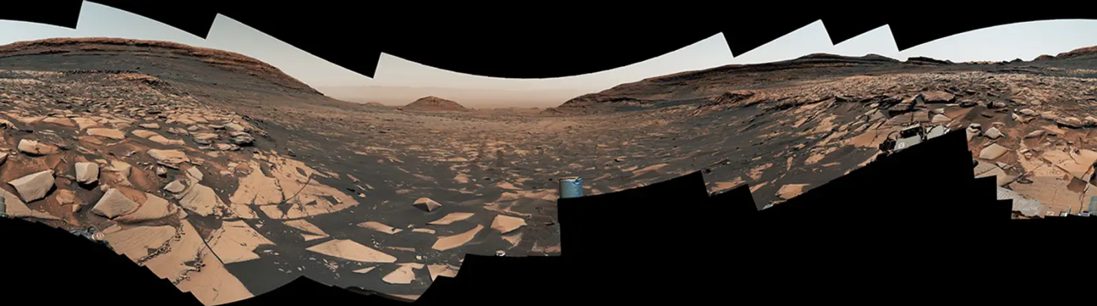
Curiosity has been working inside Gale Crater since 2012. Its route has taken it from ancient lakebed sediments to slopes marked by channels, ridges and mineral veins. The rover’s latest panorama, assembled from 323 Mastcam images, shows the scale of the climb and the broken terrain that still lies ahead.
Mount Sharp is not a single solid block of rock. It is a stack of layers built over time as wind, water and sediment filled parts of the crater and later stripped them away. The exposed slopes act like pages in a geological book. Lower layers preserve one chapter of Mars’ past; higher layers record what happened as the climate and the availability of water changed.
The rover’s instruments can test that story at close range. Cameras map the shape of the ground, the drill collects powdered rock and the spectrometers identify minerals. Curiosity’s chemistry measurements have already shown that ancient environments in Gale Crater contained water and the ingredients needed for complex chemical reactions.
The new elevation milestone also changes the questions scientists can ask. At lower levels, the focus was on whether a long-lived lake once occupied the crater. Higher up, researchers can compare minerals altered by water with rocks that formed in drier or more acidic conditions. The transition may reveal whether Mars became less hospitable gradually or in a series of shifts.
The rover is also looking for the chemical fingerprints of groundwater. Some minerals form only when water circulates through rock for long periods, while others point to brief surface flows. By measuring them in successive layers, scientists can estimate how often water returned and whether it moved through the ground or pooled in open lakes.
The panorama is useful because it places those individual samples in a larger setting. A vein or outcrop can look puzzling when seen from a few metres away. From the ridge, scientists can relate it to valleys, scarps and layers that continue across the mountain. That context helps distinguish a local event from a change that affected the wider region.
Curiosity’s progress is also a practical guide for future missions. The rover is slow, but it can choose a route around hazards, stop to examine a promising rock and return to a site if new data change the interpretation. Our overview of how a robot-first Mars outpost could be built looks at the machines that may prepare a future landing site; Curiosity shows what a single mobile laboratory can accomplish when it is given time to climb.
That flexibility has a scientific cost and a benefit. A drive planned months in advance can be interrupted when a rock looks different from orbit, but every detour uses time and energy. The team has to decide which outcrops are worth a close inspection and which can be documented from a distance, a trade-off that will shape the route for the rest of the mission.
The rover still has a difficult path. Steep slopes, loose material and sharp rocks can limit where it can drive. NASA’s team plans each movement from images and terrain models, balancing scientific targets against the need to keep the vehicle’s wheels and instruments safe.
After fourteen years on Mars, Curiosity is still turning elevation into evidence. The kilometre it has gained is a route through changing rocks, and the new panorama gives researchers the map they need to decide which layer should come next.