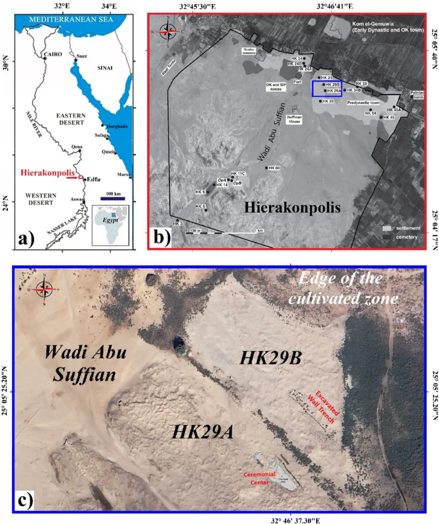
At Hierakonpolis, one of Egypt’s earliest urban and ceremonial centres, archaeologists have mapped a substantial buried structure without opening a broad excavation trench. A new study in Scientific Reports uses high-resolution ground-penetrating radar (GPR) to identify what the researchers interpret as a large wooden palisade beside a Predynastic ceremonial complex.
The result does not reveal a forgotten palace or a city wall. It offers something more useful: a clearer picture of how people organised one of the Nile Valley’s most important ritual landscapes more than 5,000 years ago.
Reading the ground without digging it up
GPR works by sending short pulses of electromagnetic energy into the ground and recording the reflections that return. Changes in soil, buried cuts, packed surfaces and other features can produce distinct signals. Archaeologists can then build horizontal “slices” of the subsurface and compare them with what is already known from excavation.
That approach matters at Hierakonpolis. The site covers a large area, and the remains are unevenly preserved. A radar survey can show where the most promising features lie before archaeologists decide where a careful excavation will add the most information.
A ceremonial centre and a second enclosure
The survey focused on the area around HK29A, a Predynastic ceremonial centre associated with some of the earliest evidence for organised ritual activity in Upper Egypt. About 50 metres to the north, the radar data revealed a broad set of linear and negative features that the team links to HK29B, an adjoining structure or enclosure.
The pattern is consistent with a substantial wooden palisade. The posts appear to follow a north-west to south-east alignment, suggesting that this was not a random scatter of timber. It was a planned boundary or enclosure built into the site’s wider layout.
Because wood normally disappears in the archaeological record, the radar is not detecting a standing fence. It is detecting the traces left by the features cut into or pressed against the ground. The interpretation is therefore a model based on the shape, spacing and orientation of the anomalies, supported by the site’s excavated context.
What the discovery changes
Hierakonpolis is often discussed as a place where the social and political structures of early Egypt began to take shape. A sizeable enclosure next to a ceremonial centre fits that picture, but it also adds an important detail: ritual activity was being managed through architecture and controlled space.
A palisade could have marked a limit, guided movement, protected a special area or helped organisers separate ordinary activity from ceremonies. The radar cannot tell us which of those functions was primary. It does show that the people using the site invested labour in shaping the approach to the ceremonial complex.
This is the kind of evidence that helps archaeologists move beyond the old divide between “ritual” and “settlement.” A ceremonial place still needed paths, boundaries, workers and maintenance. The people who built and used HK29A were negotiating all of those practical questions at once.
Why the radar result still needs excavation
GPR is powerful, but it is not a substitute for excavation. A reflection can show that something is buried without revealing its material, exact date or purpose. Soil moisture, later disturbances and the limits of the survey can also affect the picture.
The next step is targeted fieldwork. Excavation in the clearest sections of the enclosure could recover post impressions, associated surfaces or artefacts that test the palisade interpretation. It could also show whether HK29B was a single phase of construction or part of a longer sequence of changes at the site.
That caution is important. The study maps a strong archaeological pattern; it does not claim that every radar anomaly is a preserved post or that the entire outline of the enclosure is known.
Hierakonpolis in the wider story of early Egypt
The finding adds another piece to a site already central to the study of Egypt before the pharaohs. It can be read alongside the evidence for early cities, changing ritual spaces and the methods archaeologists use to date a dig. It also shows why non-invasive surveys are becoming so valuable: they allow researchers to investigate large, fragile landscapes while limiting the amount of ground they disturb.
For now, the most defensible conclusion is a measured one. At Hierakonpolis, radar has identified the likely remains of a large, deliberately aligned wooden enclosure beside a Predynastic ceremonial centre. Excavation will determine exactly how it was built and used. The map, however, already makes one point clear: the people who gathered at this early Egyptian centre were organising space on a scale that deserves a closer look.