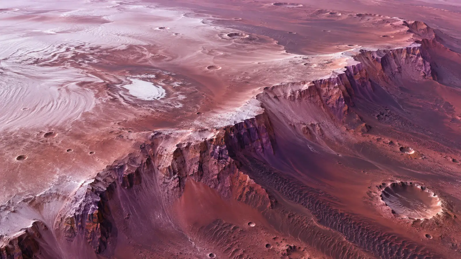
A Mars Express view of Thyles Rupes near the south pole reveals kilometre-high cliffs, frozen dunes and a landscape shaped by cooling, dust and frost.
Mars is usually pictured in rust, ochre and brown. So what are we looking at when a new view of the Red Planet turns berry-purple?
The answer is not a single strange mineral or a hidden ocean. For context, our guide to why Mars is red explains the iron-bearing dust behind the familiar colour. A new image from the European Space Agency’s Mars Express combines colour data from its High Resolution Stereo Camera (HRSC) with a view of Thyles Rupes, a long system of steep scarps in Mars’s southern highlands. The purple, pink and red tones come from several things being seen together: volcanic minerals, airborne dust, frost and the angle of the light.
That combination makes the image more than a beautiful landscape. It is a reminder that a planetary surface can change dramatically depending on what the camera measures and how sunlight reaches it.
What is Thyles Rupes?
Thyles Rupes is a group of elongated cliffs near Mars’s south pole. In places, the scarps rise more than one kilometre above the surrounding terrain and extend for hundreds of kilometres. “Rupes” is Latin for cliff or steep slope; “Thyles” refers to Thule, a legendary land beyond the edge of the known world in ancient Greek geography.
The cliffs are thought to be tectonic. As the young Mars cooled, its crust contracted and sections of the surface were pushed against one another. The result was not Earth-like plate tectonics, but enormous faults and scarps that still cut across the southern highlands.
The new HRSC image also helps with relative dating. Some impact craters are sliced by the escarpment, showing that they were already there when the cliff formed. Other craters sit on top of the scarp and must be younger. A landscape can therefore preserve a sequence of events without providing a single exact age for each one.
Why does the landscape look purple?
The colour is a mixture rather than a new “purple rock.” Darker areas contain mafic volcanic minerals such as olivine and pyroxene. On Earth, related minerals are common in the mantle. Mars’s oxidised iron supplies the familiar red background, while dust and frost alter the way the surface reflects light.
Mars Express imaged the region during martian spring. At that season, carbon-dioxide frost can remain on dunes and inside craters near the polar cap. The pale deposits sit beside darker volcanic sand, and the soft morning light passes through a dusty atmosphere. The camera records that combination as pink, violet and red. A related Curiosmos report examines a possible warm layer beneath Mars’s south pole and what it could reveal about the planet’s lost heat: read the south-pole interior study.
This is why the same place can look different in another image. A colour composite is not a photograph taken by an astronaut’s eye. It is a measured view assembled from several channels, each sensitive to a different range of light. The colour still describes real differences in the terrain, but it needs to be read alongside the instrument and processing details.
What can the dunes tell us?
The view contains more than cliffs. Dark sand has fallen from escarpments and crater walls, then been moved by winds across the polar landscape. The HRSC data show longitudinal dunes, transverse dunes and crescent-shaped barchanoid ridges.
Those forms record wind directions. A single dune type may reflect one dominant flow, while a mixture suggests that winds have arrived from different directions over time. Carbon-dioxide frost can cover the dunes even while Mars is in spring, adding another temporary layer to a surface that is already being reshaped by dust.
The image therefore brings several timescales together. The faults preserve deformation from the early cooling of Mars. The impact craters mark later collisions. The dunes record continuing wind transport, while seasonal frost comes and goes today.
Why does a camera need 3D as well as colour?
HRSC is a stereo camera. It observes the same surface from different angles as Mars Express moves along its orbit, allowing researchers to build digital terrain models. Those models help separate a high ridge from a hollow and show how cliffs, craters, dunes and ice fit together.
That matters because lighting can fool the eye. A bright patch near the bottom of the image may look like a depression when it is actually a mound. The elevation data provide a second way to test what the eye thinks it sees.
Mars Express has been mapping Mars since its 2003 launch and began science operations in 2004. More than two decades of observations allow researchers to compare new scenes with older views rather than treating every striking picture as an isolated discovery.
The purple Thyles Rupes landscape is not evidence that Mars has suddenly changed colour. It is a window into how geology, wind, frost and light meet on another world—and into how much a planetary image can reveal when we ask what each colour is really measuring.
Sources and further reading
- European Space Agency, “Purple swirls on the Red Planet” (16 September 2026): ESA source
- ESA/DLR/FU Berlin, “Raspberry ripples near Mars’s south pole” (16 September 2026): image record
- German Aerospace Center (DLR), “Thyles Rupes – the ‘legendary land’ in the south of Mars” (16 September 2026): DLR source
- DLR, “HRSC – High Resolution Stereo Camera”: instrument overview