If you search for pyramids in America, the first surprise is that the word covers more than one building tradition. In what is now the United States, Indigenous societies raised enormous earthen platform mounds beside plazas, houses and rivers. In Mexico and farther south, other societies built stepped temple pyramids, often enlarging them over earlier sacred buildings. So, are there pyramids in America? Yes—but the answer depends on what we mean by “pyramid.”
How many pyramids are in America?
There is no single reliable count. “America” can mean the United States or the entire Americas, and archaeologists do not classify every mound, ridge or platform in the same way. The seven sites below are documented examples, not a complete census; their materials and functions differ.
Where are the best-known examples?
This quick guide separates the sites by place, material and surviving form. It is a starting map, not a claim that every mound or earthwork belongs in the same category.
Cahokia
Location: Illinois, near St. Louis
What survives: A Mississippian urban centre with platform, ridgetop and conical mounds; Monks Mound is the largest surviving platform mound.
Period: Flourished around AD 1000–1350
Moundville
Location: Central Alabama, on the Black Warrior River
What survives: A planned Mississippian settlement with 32 platform mounds arranged around a plaza.
Period: Occupied around AD 1000–1450
Etowah
Location: Near Cartersville, Georgia
What survives: A ceremonial centre with three large platform mounds, a village area and an enclosing ditch.
Period: Mississippian phases, roughly AD 1000–1500
Poverty Point
Location: Northeastern Louisiana
What survives: Large mounds and sweeping ridges arranged around an open centre—an earthwork landscape, not a stone pyramid.
Period: Roughly 1700–1100 BCE
Cholula
Location: Puebla, Mexico
What survives: A huge, layered temple pyramid built through successive construction stages.
Period: Built and enlarged over many centuries
Tikal
Location: Northern Guatemala
What survives: Maya temple pyramids, palaces and plazas within a major ceremonial city.
Period: Classic Maya centre
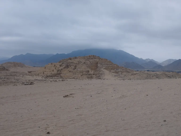
Caral-Supe
Location: Supe Valley, Peru
What survives: An early urban centre with six large pyramidal structures and sunken circular plazas.
Period: Roughly 3000–1800 BCE
Look closely at the table and the pattern changes. A Cahokia or Moundville mound is an earthen platform that could carry a building or stage a ceremony. Cholula and Tikal are stepped temple traditions. Poverty Point is a carefully planned network of ridges and mounds. Calling all of them “pyramids” can start the conversation, but the materials, dates and purposes are where the real story begins.
Where are ancient pyramids in the United States?
The best-known examples are Indigenous earthen platform mounds, including Monks Mound at Cahokia in Illinois, Moundville in Alabama and Etowah in Georgia. They differ from the stone-faced temple pyramids of Mexico.
These are site occupation or flourishing periods, not exact construction dates for every mound. The linked site authorities provide fuller background and current visiting information. For scale, Monks Mound rises about 100 feet (30.5 meters). Its terraced earthwork supported activity above a much larger settlement. An earthen surface does not mean a hidden Egyptian-style stone pyramid lies underneath. Searches for American pyramids can also bring up modern buildings and memorials. This guide concerns ancient Indigenous monuments. Their builders, materials and functions are what make the comparison useful.
What counts as a pyramid in North America?
Researchers often use more precise terms than “pyramid.” A platform mound may support a temple or a ruler’s residence without having the sharp triangular profile associated with Egypt. An earthwork can combine ridges, plazas, ramps and mounds into a planned ceremonial landscape. In Mesoamerica, a pyramid usually served as the base for a temple, with a broad staircase leading to the summit. These differences matter. A list that calls every mound a pyramid can make the sites sound more alike than they were. It also hides the engineering decisions that made each monument possible.
Poverty Point: monumental earthworks in Louisiana
Poverty Point, in northeastern Louisiana, was built by a society of hunter-fisher-gatherers between roughly 1700 and 1100 BCE. The site includes large mounds and several sweeping ridges arranged around an open central area. The National Park Service describes it as an exceptional achievement in earthen construction, created long before the rise of the famous cities of the Mississippian period. Poverty Point is not a stone pyramid and should not be presented as one. Its importance lies in the scale and organisation of the landscape. People moved huge amounts of earth, shaped the ridges into a repeated plan, and brought in stone and other materials from distant regions. The site suggests gatherings, exchange and ceremonial activity, even though the community’s name and language are unknown.
Cahokia and Monks Mound
Near present-day St. Louis, Cahokia became the largest known pre-Columbian urban centre north of Mexico. Its people built dozens of earthen mounds, plazas and neighbourhoods across a floodplain near the Mississippi River. Monks Mound, the largest of them, is a massive flat-topped platform rather than a pointed pyramid. The distinction does not make it less impressive. A platform mound could carry a temple, a ruler’s residence or a stage for public ceremonies. Its broad terraces turned the act of climbing into a movement through a carefully arranged civic landscape. The National Park Service describes Cahokia as evidence of complex social and economic development among Indigenous Americans before European contact. Cahokia also shows why architecture cannot be separated from settlement. The mound stood inside a city with plazas, houses, craft production and long-distance exchange. The monument was one part of a political and religious centre, not an isolated mystery built by an unknown race.
Cholula: the largest pyramid by volume
In Puebla, Mexico, the Great Pyramid of Cholula—known in Nahuatl as Tlachihualtépetl, or “the handmade mountain”—looks at first like a natural hill. It is a layered monument built over earlier structures, with a base extending roughly 450 metres on each side. By volume, it is commonly described as the largest pyramid in the world, although Giza remains much taller and better preserved above ground. Mexico’s national heritage institute (INAH) explains that Cholula’s pyramid was dedicated to Tlaloc and grew through several construction stages. Later people built a church dedicated to Our Lady of Remedies on its summit. The result is not a simple story of an abandoned monument: the mound remained part of a living sacred landscape, even after the Spanish conquest changed its meaning. Our guide to the Great Pyramid of Cholula looks more closely at the buried structure and why its size is so often misunderstood.
Mesoamerican pyramids were temple platforms
Cholula belongs to a wider Mesoamerican tradition that includes Teotihuacan, the Maya cities, Monte Albán, Tenochtitlan and many smaller centres. These pyramids were usually stepped and crowned by temples. Their stairs, plazas and balustrades directed movement and made ceremonies visible to large crowds. They were also rebuilt. A later ruler could enlarge an older temple by placing a new structure over it, preserving part of the earlier sacred building inside the new one. That practice explains why dimensions and dates can be difficult to reduce to a single number. A “pyramid” may be a stack of political decisions made over centuries.
What about pyramids farther south?
At Tikal in northern Guatemala, Maya temples and palaces formed part of a large ceremonial center. Farther south, Caral-Supe in Peru includes six large pyramidal structures among its monumental architecture. These examples extend the story beyond the U.S. mound centers and Mexico, while showing why a single count of “pyramids in America” depends on what a source chooses to classify as a pyramid.
Why did Indigenous societies build monumental mounds?
The answer varied from place to place. Monumental earthworks could mark a ceremonial calendar, provide a stage for public ritual, support a temple or residence, organise a plaza, or make a community’s labour visible. They also created high ground in landscapes shaped by rivers, wetlands and seasonal flooding. Construction required planning and cooperation, but the presence of a large mound does not automatically prove a centralised empire. Poverty Point, Cahokia and Mesoamerican capitals had different political systems. The monuments tell us that people could coordinate labour; they do not, by themselves, tell us exactly how authority worked.
Were North American pyramids connected to Egypt?
There is no archaeological evidence that Egyptian builders travelled to North America and taught Indigenous societies how to construct pyramids. Similar shapes can arise independently because broad, stable platforms are useful for temples, ceremonies and elite buildings. The documented connections are regional: Mississippian mound traditions developed within North America, while Mesoamerican pyramid traditions developed through long local development. Independent development does not make the monuments less remarkable. It makes the comparison more interesting. Different societies solved comparable problems with local materials, local beliefs and their own ideas about how a city should meet the sky.
Other North American earthworks worth knowing
Poverty Point and Cahokia are only two parts of a much larger record. Mississippian platform mounds once stood at sites such as Moundville in Alabama and Etowah in Georgia. In Mexico, Monte Albán, Teotihuacan and the Mexica capital of Tenochtitlan used platforms, terraces and pyramidal temples to organise civic and sacred space. Many sites are smaller than Cholula or less intact than Cahokia, but they reveal the same commitment to shaping the landscape. Several of these places were damaged by farming, roads, looting and the assumption that earthen architecture was merely a natural hill. Archaeological surveys now combine excavation, mapping and remote sensing to identify buried walls, plazas and earlier construction phases.
What the monuments tell us
The pyramids and earthworks of North America do not point to a single lost civilisation. They point to many societies with their own traditions. A shell-free earthen ridge at Poverty Point, a platform mound at Cahokia and the layered temple base at Cholula cannot be judged by the same ruler. They can, however, be read together as evidence of Indigenous engineering. The builders understood soil, water, transport, geometry, ceremony and the social power of a public monument. Their work survived in different ways—sometimes as a visible hill, sometimes as a buried city and sometimes as a temple base still used in a transformed landscape.