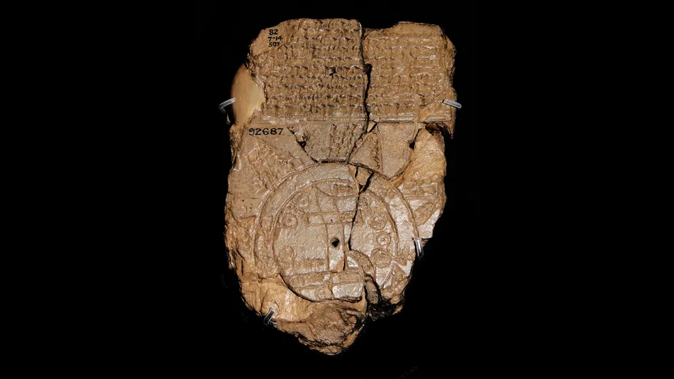
What does the Babylonian Map of the World show? The small clay tablet known as the Imago Mundi records a Babylonian view of the world in which geography, political memory and myth sit on the same surface. It is not a modern map of the planet, but it is one of the clearest surviving windows into how a Mesopotamian scholar organised the world around Babylon.
The tablet is usually dated to the sixth century B.C., in the late Babylonian or early Achaemenid period. The British Museum identifies it as a clay tablet from Sippar, written in Akkadian. Its lower edge is damaged and parts of the accompanying inscription are difficult to read, so every interpretation has to leave room for uncertainty.
How the map is arranged
The drawing presents the known world as a disk surrounded by a ring of water called the Bitter River. Babylon appears prominently near the Euphrates, while other places, including Assyria and the land of Urartu, are marked within the surrounding geography. The Euphrates is shown as a major line through the map, linking the city-centred world to the marshes and the sea.
That circular outline should not be mistaken for a claim that Babylonian observers believed the Earth was a flat coin floating in space. The tablet is a schematic image. It selects places and relationships that mattered to its makers rather than trying to preserve coastline, distance and scale in the way a navigation chart does.
Map and myth are not separate here
The writing on the reverse is part of the object’s meaning. It refers to regions beyond the central map and to extraordinary places associated with the edge of the world. The tablet therefore combines practical geography with a larger cosmological story. For a Babylonian reader, describing the world also meant describing the order that made the world intelligible.
Babylon’s prominence is not an accident. The city was a political and religious centre, and the map reflects that point of view. It is a map of a civilisation’s world, not a neutral survey produced from nowhere. That is why the tablet is valuable even where its geography is symbolic: it shows which places were remembered, grouped together and placed at the centre.
What the Imago Mundi cannot tell us
The tablet does not provide a complete atlas, a measurement system, or proof that every place named on it was known from direct travel. It also cannot be read as a simple prediction of modern geography. The damaged text and compressed symbols leave several labels open to debate, and translations of the Akkadian wording differ in detail.
Its importance lies elsewhere. The map is a physical record of people turning a landscape, a river system and a collection of stories into an ordered picture. It belongs beside other early attempts to represent the world, including the maps and plans discussed in our guide to six ancient maps.
Why the tablet still matters
The Imago Mundi does not show the world as it is. It shows a particular community deciding what the world was. That distinction is the reason the tablet remains so compelling: its small circles, river line and surrounding water preserve a worldview, not just a set of place names.
A map for whom?
The tablet was not made for a traveller who needed turn-by-turn directions. It was more likely a learned object, combining a diagram with explanatory writing for readers who already understood Babylonian geography and religious language. The decision to place Babylon near the centre tells us about political imagination as much as cartography. A map can measure a road, but it can also express belonging.
That is why the Imago Mundi should be read alongside the tablet’s material details. Its clay surface, compact signs and damaged edges are part of the evidence. We are looking at an object handled, stored and transmitted by people who believed that describing the world was a form of knowledge.
\n
Sources: British Museum, Map of the World tablet; French Ministry of Culture, Babylonian Map of the World.