Was Atlantis located in the Sahara?
Online creators argue that the Richat Structure matches Plato’s concentric-city description, while geologists describe it as a natural dome shaped by uplift and erosion.
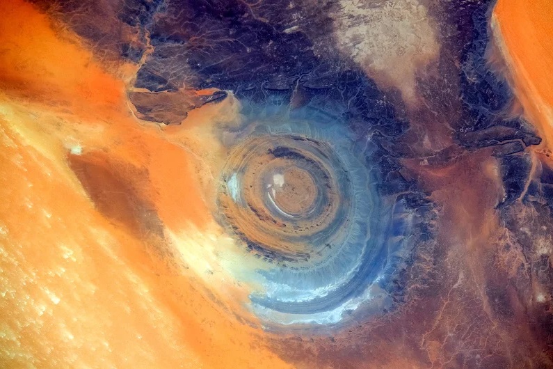
The latest surge in Atlantis speculation has focused not on the seafloor but on a bull’s-eye-shaped landform in the Sahara. Proponents of the “Eye of the Sahara” theory argue that the Richat Structure, a giant set of concentric rings in Mauritania, could preserve the footprint of the capital described by Plato.
The claim has gained traction through satellite imagery and video explainers that compare the rings to details in Plato’s account. Archaeologists and ancient-history scholars, however, generally treat Atlantis as a literary construction rather than a lost state awaiting excavation, and geologists describe the Richat as an eroded geological dome rather than the remains of a city.
A landmark visible from orbit
The Richat Structure sits on the Adrar Plateau in northwestern Mauritania, near the town of Ouadane. From space it appears as a broad target-like pattern, making it a frequent reference point in astronaut photography and Earth-observation imagery.
Basic measurements are part of the argument and part of the dispute. Scientific descriptions commonly give the formation a diameter of about 40 kilometers, while some popular presentations focus on a smaller span within the ring system. The figure cited in many Atlantis videos, roughly 23 kilometers, is typically derived by selecting specific inner rings and leaving out the full outer extent that appears in geological mapping of the structure.
Geologists have studied the Richat for decades and do not treat it as an impact crater or a built environment. Research summaries describe it as a geological uplift followed by erosion, with harder rock layers forming ridges and more erodible layers wearing down into intervening troughs. A technical overview in the geological literature characterizes the Richat as a large eroded dome with igneous intrusions and varied rock types exposed at different erosion levels, not as a basin that once held engineered canals or harbor walls (ScienceDirect paper abstract).
Plato’s Atlantis, and what it actually says
Atlantis enters the historical record through two dialogues, Timaeus and Critias, attributed to Plato and generally dated to the 4th century BCE. In the story, Atlantis is presented as a powerful maritime state located beyond the “Pillars of Hercules,” a classical term associated with the Strait of Gibraltar.
Plato’s account places Atlantis 9,000 years before the time of Solon, the Athenian lawgiver, and describes a society that rises and falls in a cautionary arc. Many modern reference works treat Atlantis primarily as a philosophical narrative device rather than a report of a recoverable place, emphasizing that later traditions largely build outward from Plato’s text rather than from independent evidence (Encyclopaedia Britannica overview).
The Richat theory hinges on specific details, especially Plato’s depiction of a circular capital organized in rings. The text describes an engineered layout of alternating land and water bands, which is why concentric landforms have long attracted attention from Atlantis seekers. Plato also describes nearby terrain as a “flat and smooth plain,” a phrase frequently cited in modern comparisons between the dialogue and large, open landscapes.
A viral case built from satellite imagery
One of the most visible online advocates of the Richat theory is a creator identified in many posts as Jimmy Bright. His argument circulates widely through the Bright Insight channel and related videos that match satellite views of the Richat with elements from Plato’s dialogues.
In the version of the claim that has spread most widely, the rings are treated as a fossilized urban plan rather than a natural pattern. Supporters point to the concentric geometry, argue that parts of the structure align with the capital’s ringed description, and interpret surrounding low-relief areas as Plato’s “flat and smooth plain.” Some versions of the theory also highlight drainage traces and dry channels across the broader Sahara as signs that water once behaved differently in the region, and they use that environmental history to argue that a settlement could have existed there in a wetter phase of the past.
The videos often frame the Richat’s scale as consistent with Plato’s measurements, and the 23-kilometer figure circulates as a headline-friendly match. In scientific descriptions, the outer structure is larger, and the central zone includes complex exposures of older rock units and intrusive bodies rather than clear signs of human construction (European Space Agency description).
Why the academic case remains thin
Even where the Richat theory sticks closely to Plato’s words, it faces a basic problem: the physical evidence expected from an urban center has not been established at the site in any public, peer-reviewed way. The viral claim rests heavily on pattern matching from orbit and on selective measurement of ring segments, rather than on excavated architecture, securely dated cultural layers, or an agreed archaeological sequence tying the formation to human building.
Geologists, meanwhile, have a straightforward explanation for the rings that does not require an ancient city. The Richat is widely described as an eroded dome in which different layers respond differently to weathering, creating circular ridges and valleys as wind and water remove material over long time spans (NASA Earth Observatory). That mechanism accounts for concentric geometry without implying engineered canals, walls, or harbor basins.
Within ancient-history scholarship, Atlantis is typically handled as a story with a purpose rather than a location with coordinates. Plato’s dialogues use the Atlantis narrative to stage political and ethical contrasts, and many scholars view the account as allegory or philosophical mythmaking rather than reportage. That approach does not require dismissing every geographical detail in the text, but it does lower the expectation that the narrative maps cleanly onto a single, findable site.
Why the theory persists
The Richat Structure is unusually vivid from space, easy to frame in screenshots, and visually compatible with a ringed-city description when viewed at the right scale. That combination makes it well suited to modern “desk archaeology,” where Google Earth and satellite layers function as the main research tools and where persuasive force often comes from imagery rather than from stratigraphy, artifacts, or dated contexts.
The result is a theory that continues to circulate even in the absence of academic consensus. Its appeal is less about a newly uncovered body of evidence than about a sense of fit between an ancient description and a striking modern landform, reinforced by repeatable visuals. In that setting, the recurring claim of “coincidences” becomes the main engine of belief, while the scientific description of the Richat as a natural formation remains the prevailing interpretation in geology and Earth science references.
For now, the Eye of the Sahara theory sits where many Atlantis claims end up: vivid, easily shared, and hard to settle decisively through argument alone, because the standards of proof differ. One side leans on textual resemblance and satellite geometry. The other asks for material traces that can be documented, dated, and independently checked, and for a geological story that does not need human builders to explain a landscape that nature can plausibly carve on its own