Curiosmos
  • Home
  • Unsolved Mysteries
  • Ancient Civilizations
  • Cosmic Phenomena
  • Alien Theories
  • Curious Lists
No Result
View All Result
Like us on Facebook
Curiosmos
  • Home
  • Unsolved Mysteries
  • Ancient Civilizations
  • Cosmic Phenomena
  • Alien Theories
  • Curious Lists
No Result
View All Result
Curiosmos
No Result
View All Result

Zealandia: Unprecedented Maps of Earth’s 8th Sunken Continent Reveal a Never-Before-Seen World

Ivan PetricevicbyIvan Petricevic
June 25, 2020 - Updated on January 21, 2024
in Editor's Picks
A map showing the countries of Australia, New Caledonia and New Zealand, as well as the continent of Zealandia, Earth's eighth continent.

A map showing the countries of Australia, New Caledonia and New Zealand, as well as the continent of Zealandia, Earth's eighth continent.

Share on FacebookShare on Twitter

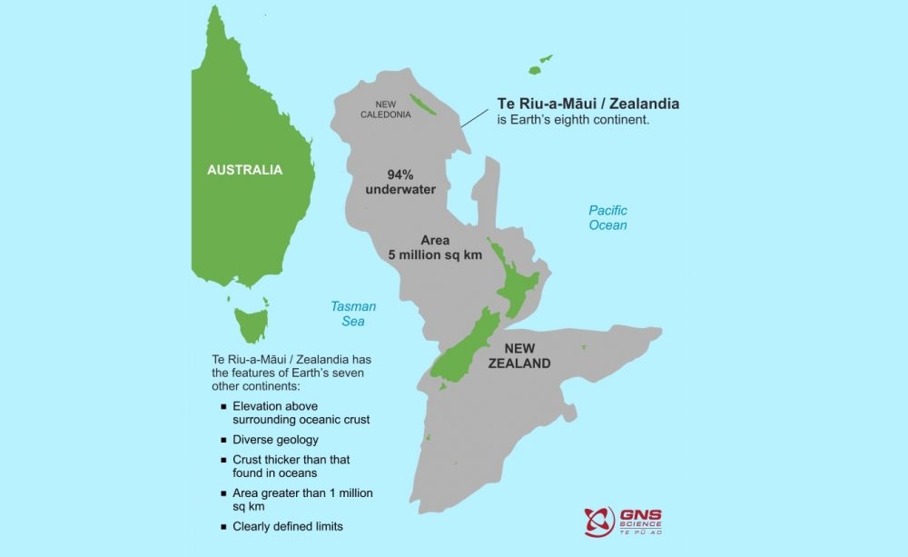
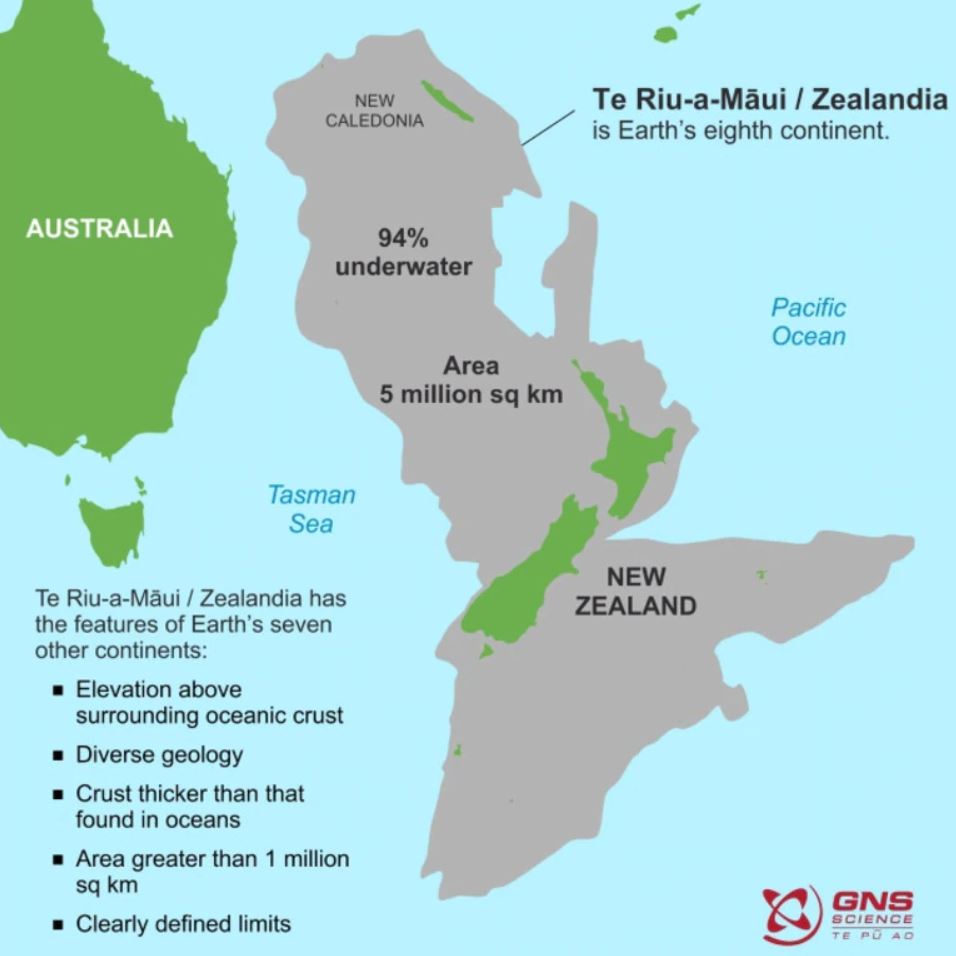
There’s a sunken continent off the coast of Australia; its name is Zealandia. You probably never heard about it, but its Earth’s eighth continent and its highest mountains are, in fact, the countries of New Zealand and New Caledonia. Around 94% of Zealandia is beneath the water, and experts have been studying the continent for years.

Only now have we obtained detailed maps of the sunken continent.


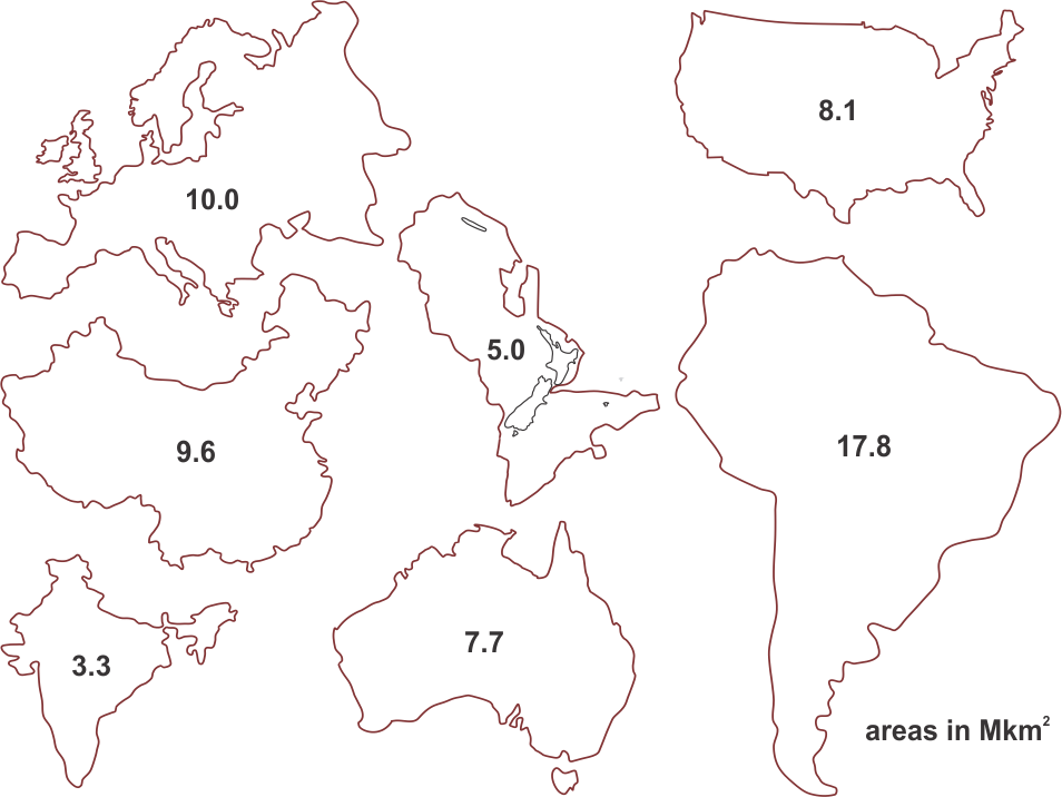
Zealandia, a sunken continent of around 5 million square kilometers, can now be explored through interactive maps. Although referred to as Zealandia in modern times, the long-lost sunken continent is known in the indigenous Māori language as Te Riu-a-Māui. The name Zealandia was coined by geophysicist Bruce Lauyendyk in 1995.

Published by GNS Science, two charts and an interactive exploration tool cover the bathymetry (shape of the ocean floor) and the tectonic origins of the eighth continent of Earth. Zealandia is home to the countries of New Zealand and New Caledonia. The massive continent was swallowed by the pacific ocean around 60 million years ago, remaining mostly underwater ever since.

Related Posts

An artists rendering showing an asteroid entering Earth's atmosphere. Shutterstock.

Global Reset 12,800 Years Ago: Evidence of Mass Extinction by Asteroid?

October 3, 2019 - Updated on May 3, 2023
44,000-Year-Old Cave Art Reveals Ancient Humans Depicted Shapeshifting Beings

44,000-Year-Old Cave Art Reveals Ancient Humans Depicted Shapeshifting Beings

December 13, 2019 - Updated on February 22, 2025

“These maps are a scientific reference point, but they are also more than that. They are a way to communicate our work to our colleagues, stakeholders, educators, and the public,” says the maps’ lead author, geologist Nick Mortimer.

The new, never-before-seen maps can now be accessed through an interactive website, where people can explore the eight continent’s tectonic profile, as well as its exact shape, and the depth of the ocean floor that encompasses it.

The maps of Zealandia provide a refreshing context through which experts have managed to explain the geology of the continent.

Zealandia is big. The outline of Zealandia compared with some other countries and regions at the same scale. Image Credit: GNS.
Zealandia is big. The outline of Zealandia (5.0) compared with some other countries and regions at the same scale. Image Credit: GNS.

“The maps offer descriptions of New Zealand’s volcanoes, plate boundary and sedimentary basins,” Mortimer said.

The recently published maps of Zealandia are actually part of a global effort to map the entire seafloor of the planet by 2030. The project, called Seabed 2030, has already mapped nearly a fifth of the world’s ocean floor.

Zealandia was discovered in the 1990s, but only now have experts managed to explore the sunken contention and publish its geological profile. Despite this, and due to its Atlantean geography, the sunken continent remains poorly studied compared to Earth’s other seven continents.

“We’ve made these maps to provide an accurate, complete, and up-to-date picture of the geology of the New Zealand and southwest Pacific area — better than we have had before,” Mortimer explained.

Zealandia, the now sunken continent, was once above the surface entirely. It was part of the supercontinent of Gondwana which held together the continents of South America, Africa, and Antarctica. Around 85 million years ago, changes in Earth’s crust and tectonic plates caused the continent to split off from Gondwana.

This Geological map shows the sunken continent of Zealandia. Image Credit: GNS.

It drifted from Gondwana, shifting its landmass along the way. Millions of years ago, Zealandia’s lush forest and river systems were home to countless dinosaurs who walked its surfaces.

Then, tens of millions of years later, the world’s tectonic place started rearranging themselves, causing drastic changes in Zealandia.

These geological changes created the Pacific Ring of Fire, a region on Earth where we find the most active volcanoes on the planet. During this time, the Pacific plate is also thought to have sunk below the continental crust of Zealandia. This created a chain of events that caused the root of the continent to split and sink.

Eventually, around 94 percent of Zealandia sank. But some parts survived, and have remained above the surface for tens of millions of years. Most of Zealandia is now New Zealand, and the continent’s highest point is Aoraki–Mount Cook at 3,724 meters (12,218 feet) above sea level.

Share157Tweet98Share27ShareSend
Ivan Petricevic

Ivan Petricevic

I've been writing passionately about ancient civilizations, history, alien life, and various other subjects for more than eight years. You may have seen me appear on Discovery Channel's What On Earth series, History Channel's Ancient Aliens, and Gaia's Ancient Civilizations among others.

Related Posts

An image with a description of the ancient Chinese astro coin. Image Credit: Primaltek.
Editor's Picks

Ancient Chinese “Astronomy Coin” Depicts How Chinese Astronomers Saw The Sky 2000 Years Ago

November 18, 2020 - Updated on January 21, 2024
The latest "UFO Patents" of the US Navy revealed unimaginable conceptual technologies and experiments that have already been made. Credit: Shutterstock
Editor's Picks

Declassified US Navy Documents Reveal “UFO Patent” and Spacetime Modification Weapon

January 27, 2021 - Updated on February 7, 2023
The incredible panoramic image made by Chang'e 5 on the Moon's surface. Credit: CNSA/CLEP
Editor's Picks

Here Are 6 Images and Videos Of The Lunar Surface Snapped By Chinese Chang’e 5 Moon Mission

December 2, 2020 - Updated on January 21, 2024
A Village and the pyramids during the flood-time, circa 1890 (Public Domain).
Editor's Picks

25 Rare Images of The Ancient Egypt’s Pyramids and Sphinx

May 20, 2020 - Updated on January 21, 2024
A stunning photograph of Comet Lovejoy. Photo: Marty Murphy, Nikolay Kuropatkin, Huan Lin and Brian Yanny; Dark Energy Survey.
Editor's Picks

Here Are The Dark Energy Camera’s Most Spectacular 15 Cosmic Images

October 5, 2022 - Updated on January 21, 2024
Image Credit: J. A. Peñas/SINC / NAIC-Arecibo / NSF
Editor's Picks

Here Are 6 of the Weirdest Asteroids Ever Found

May 24, 2019 - Updated on May 2, 2023
  • About
  • Privacy Policy
  • Fair Use Notice
  • DMCA / Removal
  • Impressum
  • Contact
  • Fact-Checking Policy
  • Ethics Policy
  • Ownership and Funding Information
  • Impressum
CURIOSMOS.COM

Welcome Back!

Login to your account below

Forgotten Password?

Retrieve your password

Please enter your username or email address to reset your password.

Log In
No Result
View All Result
  • Home
  • Unsolved Mysteries
  • Ancient Civilizations
  • Cosmic Phenomena
  • Alien Theories
  • Curious Lists